The Rocks, Sydney, New South Wales, Australia

Sydney The Rocks & Millers Point Walking Tour

This tour explores historical and cultural landmarks in The Rocks, Sydney. Highlights include Fort Philip's strategic significance, Bennelong's capture site, the Hero of Waterloo's legendary tales, and the iconic design choice of the Sydney Opera House.

Loading map...

Setting the Scene

The Rocks area in Sydney has evolved dramatically from its colonial beginnings to a vibrant urban space.
  • Colonial Beginnings: Established as one of the first European settlements in Australia, The Rocks played a central role in the country's early development.
  • Convict Labor: Much of the area was built using convict labor, leaving a lasting mark on its architecture and street layout.
  • Maritime Significance: The proximity to Sydney Harbour made it a bustling hub for trade and naval activities.
  • Urban Transformation: The area has undergone significant urban renewal, preserving historical buildings while integrating modern amenities.
  • Cultural Hub: Today, The Rocks is known for its vibrant arts scene, with galleries, museums, and cultural events drawing visitors year-round.

The Rocks Tour Stops

1. Observatory Hill Park
Fort Philip's History
Image via Wikipedia
Observatory Hill Park, located in the heart of Sydney's central business district, has a rich history dating back to 1796 when it was known as Windmill Hill. One pivotal event in its history was the construction of Fort Philip in 1804. This fort was built under the direction of Governor Hunter to defend the settlement against potential French attacks and insurrections by Irish rebels[1][2]. Despite its intended purpose, Fort Philip was never used for defense and gradually fell into disuse. By the 1850s, it was partially demolished[2].

The remains of Fort Philip are still visible today as part of the eastern rampart of the Signal Station, which was built in 1847. This station played a crucial role in communication with ships in the harbor using flags and semaphores[3][2]. The site's transformation from a defensive structure to a communication hub reflects the evolving needs of the colony. Today, the area is home to several historical buildings, including the Sydney Observatory, which was built in 1858 and continues to serve as a museum and public observatory[2][1].
2. Susannah Place Museum
Saving Susannah Place
Image via Wikipedia
Susannah Place, located at 58-64 Gloucester Street in The Rocks, Sydney, is a historic terrace of four houses built by Irish immigrants in 1844[1][2]. By the 1970s, it faced demolition due to redevelopment plans by the Sydney Cove Redevelopment Authority (SCRA)[1]. However, in 1978, the Rocks Resident Action Group and the Builders' Labourers Federation imposed a "Green Ban" on the area, preventing its destruction[1].

This decision was pivotal as it marked one of the first times a Green Ban was used in a working-class neighborhood, with the state government as the opponent[1]. The ban led to negotiations between the SCRA and the Historic Houses Trust of New South Wales, resulting in the Trust's interest in acquiring the property for its historical significance[1]. Conservation work began in 1987, preserving Susannah Place as a museum that now tells the stories of its past occupants and the community's fight to save it[1][2].

Physical evidence of the site's history remains intact, including layers of paint and worn handrails, which provide a glimpse into the lives of the families who lived there[2]. The preservation of Susannah Place not only saved a piece of The Rocks' heritage but also highlighted the power of community action in protecting cultural and historical sites.
3. Argyle Cut
Argyle Cut Completion
Image via Wikipedia
The Argyle Cut, located in Sydney's The Rocks, is a significant historical and engineering landmark. Initially, construction began in 1843 using convict labour under the supervision of Tim Lane, but it was abandoned due to the inefficiency of hand tools and public dissatisfaction with the sight of chained convicts[1][2]. The project resumed in 1859 when the Sydney Municipal Council took over, employing paid labour and explosives to complete the cut[1][2]. This shift marked a crucial moment in Sydney's urban development, as it provided a direct link between The Rocks and Millers Point, facilitating transportation and commerce[1][2].

The completion of the Argyle Cut involved significant physical challenges, as it required cutting through a massive sandstone ridge. The use of explosives was a key factor in overcoming these geological obstacles[1]. Once completed, the cut became an essential infrastructure component, supporting the growth of Sydney's maritime and mercantile sectors[2].

Physical evidence of the Argyle Cut's historical significance includes the remaining sandstone walls and the inscription on the cut's south wall, which references the completion of overhead bridges in the late 19th century[2]. The cut's modifications over time, such as the construction of bridges and realignments, reflect Sydney's evolving urban landscape and infrastructure needs[2].
4. Garrison Church
Garrison Church Mistakes
Image via Wikipedia
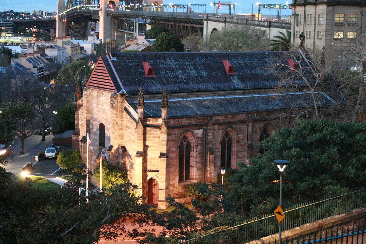
The Garrison Church, originally known as Holy Trinity Anglican Church, is located in Millers Point, Sydney. It was the first military church in Australia, serving regiments stationed in the city[1]. The church's construction began in 1840, using local stone, and was completed in 1843[1]. However, two significant mistakes occurred during its construction. The church was built with an East to West orientation instead of the planned North to South, which turned out to be a fortunate mistake as it allows morning sunlight to illuminate the interior beautifully[1]. Additionally, the church was not consecrated until 2000, 140 years after its construction[1].

The church's military connection is evident from its history of hosting the Red Coats of the 50th Queens Own Regiment at Dawes Point Battery[2]. It also served as a place of education for notable figures like Sir Edmund Barton, who received his primary education at the church's parish hall[2]. Today, the church houses a small museum displaying military memorabilia and plaques dedicated to various Australian regiments[1]. Despite its historical significance, the church was amalgamated with St. Phillip's Parish in 2013 due to its small size[3].
5. The Hero of Waterloo Hotel
Hero of Waterloo
Hero of Waterloo
Hero of Waterloo
Image via Wikipedia
The Hero of Waterloo Hotel, located in Millers Point, Sydney, is one of the oldest continuously trading hotels in Australia. Built between 1843 and 1844 by George Paton, a stonemason who also constructed the nearby Garrison Church, it was first licensed in 1845[1][2]. The hotel's early clientele included the crews of whaling and sealing vessels that docked at Millers Point, making it a significant social hub for the community[3].

In 1901, Sydney faced a severe outbreak of bubonic plague, leading to widespread demolitions and resumptions by the Sydney Harbour Trust. Despite this, the Hero of Waterloo survived, unlike many other hotels that were demolished due to their poor condition or revoked licenses following the Liquor Act of 1912[1]. The hotel's survival was partly due to its historical significance and architectural integrity, which have been preserved to this day.

The hotel's design is characteristic of the Old Colonial Regency style, featuring sandstone walls and a hipped iron roof. It retains much of its original form, including exposed stonework and original timber joinery[1][3]. While rumors persist about a hidden tunnel leading to Darling Harbour, these claims remain unsubstantiated[1]. Nonetheless, the Hero of Waterloo remains an integral part of Millers Point's history and culture.
6. Colonial Quarters
Bennelong's Capture
Bennelong's Capture
Bennelong's Capture
Image via Wikipedia
Bennelong Lawn, part of the Quay Quarter in Sydney, is closely associated with the historical figure Bennelong, an Aboriginal man who played a significant role in early Australian history. In November 1789, Bennelong was captured by order of Governor Arthur Phillip, who sought to establish communication with the indigenous Eora people[1][2]. This event marked a pivotal moment in the history of the region, as it aimed to facilitate cross-cultural understanding.

The capture was part of Phillip's broader strategy to learn about the customs and language of the local Aboriginal population. Bennelong, along with Colebee, was taken to the settlement at Sydney Cove. While Colebee soon escaped, Bennelong remained for several months, during which he began to adapt to life among the British[1][2].

Bennelong's interactions with the British were complex and multifaceted. He learned English, developed a taste for British food and liquor, and became attached to Governor Phillip, who housed him[2]. However, his relationship with the British was not without tension. In 1790, an incident involving the spearing of Governor Phillip occurred, which some historians interpret as a ceremonial act of conciliation[1].

Today, physical evidence of Bennelong's presence in the area includes Bennelong Point, where a brick hut was built for him in 1791, and Bennelong Bridge, which crosses Homebush Bay[1][2]. These landmarks serve as reminders of Bennelong's role in early Australian history and his efforts to bridge two cultures.
7. Cadman's Cottage
Cadmans Cottage Restoration
Image via Wikipedia
Cadmans Cottage, located in The Rocks area of Sydney, is one of the oldest surviving buildings in the city, dating back to 1816. Originally built as a residence for government coxswains, it later served as the headquarters for the Sydney Water Police and then as a Sailors Home[1][2]. In the early 1970s, Cadmans Cottage underwent significant restoration work, which, although well-intentioned, removed much of the historical evidence of its past uses. This restoration was part of a broader effort to preserve historical sites in Sydney, following public pressure to save the cottage from demolition[1][2].

The restoration process, led by architects Philip Cox, Storey and Partners, involved the demolition of annexes and internal partitions. However, the work was poorly documented, making it difficult to ascertain the full extent of changes made to the building[1]. Despite these challenges, Cadmans Cottage remains a significant historical site, offering insights into Sydney's maritime past and the evolution of its waterfront[2].

The cottage's transformation over time reflects broader changes in Sydney's urban landscape. Initially situated on the shoreline, land reclamation projects moved the harbour 100 metres away from the cottage[1]. Today, Cadmans Cottage serves as a visitor attraction and a reminder of Sydney's early colonial history[3].
8. The Fortune of War
Plague and Rebuilding
Image via Wikipedia
The Fortune of War Hotel, located in The Rocks area of Sydney, has a rich history dating back to 1828. However, a pivotal moment in its history occurred in 1900 when a bubonic plague outbreak ravaged the waterfront area. This led to large-scale demolitions and the eventual rebuilding of the hotel in 1922 by Tooth & Co. Brewery[1][2].

The plague outbreak prompted the NSW Government to resume control of The Rocks and Millers Point, leading to significant changes in the area's infrastructure. The Sydney Harbour Trust administered the area, overseeing the demolition of old buildings to prevent the spread of disease[1].

In 1921, the new Fortune of War Hotel was constructed on the same site, reflecting a shift towards more modern and sanitary architecture. The building's design, inspired by the Californian Bungalow style, was typical of commercial hotels from the 1920s and 1930s[1].

Today, the hotel remains a significant part of The Rocks' heritage, with its original features still intact. The site's historical significance is further highlighted by its inclusion on the New South Wales State Heritage Register in 2002[1][3].
9. First Fleet Park
Founding of Australia
Image via Wikipedia
First Fleet Park, located in The Rocks, Sydney, is a public space closely associated with the founding of Australia. The park is situated near the site where the First Fleet, a fleet of eleven British ships, arrived in 1788, marking the beginning of European colonization in Australia[1][2]. The First Fleet, under the command of Captain Arthur Phillip, initially landed at Botany Bay but later moved to Port Jackson, establishing the colony of New South Wales[1].

The decision to establish a British settlement in Australia was influenced by the need for a Pacific base and the cessation of convict transportation to North America following the American Revolution[1]. This pivotal moment in Australian history is commemorated in various ways throughout The Rocks area, including First Fleet Park, which offers panoramic views of Sydney's iconic landmarks like the Opera House and Harbour Bridge[3].

The park itself is a grassy open space used for passive leisure activities and is designed to accommodate pedestrian circulation and temporary events[3]. Its proximity to the Museum of Contemporary Art and Circular Quay makes it a significant public space in Sydney's cultural landscape.
10. Sydney Writers Walk
Sydney Writers Walk
Sydney Writers Walk
Sydney Writers Walk
Image via Wikipedia
The Sydney Writers Walk is a series of 60 circular metal plaques located between the Overseas Passenger Terminal and the Sydney Opera House forecourt. Established in 1991 by the NSW Ministry for the Arts, it honors both Australian and international authors who have a connection to Australia[1]. The walk was extended in 2011 with the addition of 11 more plaques, featuring writers like Morris West and David Williamson[1].

One of the intriguing aspects of the walk is its inclusion of overseas authors such as D. H. Lawrence and Mark Twain, who either lived in or visited Australia. This reflects the global literary influence on Australian culture[1][2].

Despite its cultural significance, the walk faces challenges in maintaining up-to-date information. For instance, many plaques do not include the death dates of featured authors, such as Thea Astley and Judith Wright[1]. This oversight highlights the need for ongoing maintenance to ensure the walk remains a relevant and accurate tribute to literary figures.

The design of the plaques and their placement along the walkway was chosen to create a visually appealing and accessible cultural resource. The circular metal plaques are embedded in the footpath, providing a unique blend of art and literature that engages visitors as they explore the area[1][2].
11. Sydney Opera House
Iconic Design Choice
Image via Wikipedia
The Sydney Opera House, located on Bennelong Point in Sydney, Australia, is renowned for its distinctive design. In 1957, an international competition was held to select the design for the building. Danish architect Jørn Utzon's innovative design was chosen from among 233 entries. This decision marked a pivotal moment in architectural history, as it introduced a unique and innovative design that became a symbol of Australia.

The construction of the Sydney Opera House faced numerous challenges, including significant cost overruns and engineering difficulties. Initially expected to cost $7 million, the project ultimately cost $102 million. Despite these challenges, the building was completed in 1973 and has since become an iconic landmark.

The Sydney Opera House is not only a venue for opera but also hosts a wide range of events, including concerts and theater performances. This versatility showcases the building's ability to adapt to different uses beyond its original purpose.

Today, the Sydney Opera House is recognized as a UNESCO World Heritage Site, highlighting its cultural and architectural significance. The location of the building on Bennelong Point has been subject to environmental considerations, including the preservation of the surrounding harbor ecosystem.
12. Man O' War Steps
Naval Embarkation Point
Image via Wikipedia
Man O'War Steps, located in Sydney, Australia, is a historically significant site that served as a crucial embarkation and landing point for British and Australian naval personnel. Originally built during the early 19th century under Governor Lachlan Macquarie, the steps were part of a stone jetty used for naval purposes[1][2]. Over the years, the steps played a pivotal role in major conflicts, including World War I and II, Korea, Malaya, and Vietnam. A plaque commemorates the 2,215 officers and sailors who left from these steps and never returned[1].

The steps were reconstructed in the early 1970s to coincide with the opening of the Sydney Opera House, ensuring their historical significance was preserved[1][2]. This reconstruction maintained the original purpose while adapting to modern needs. Today, the area is a popular spot for harbour cruises and offers a glimpse into Sydney's naval past[1].

The steps' design reflects their original purpose as a connection between land and sea. The stone jetty and steps were built to facilitate the movement of personnel and supplies to and from naval vessels anchored in Sydney Harbour[1][2]. This historical context is preserved through memorial plaques and the structure itself, which remains a significant part of Sydney's maritime heritage[1].

Storydex uses AI to create historical stories based on multiple sources, with citations for further exploration. While we strive for accuracy, please verify important details. We're always improving, so if you spot an error or have feedback, let us know!

Liked this tour?

The Storydex app lets you discover stories nearby, not just in this city, but anywhere.